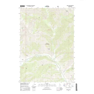
2017 Map of Amber Lakes
USGS Topo · Published 2017About this map
Sawtooth National Forest dominates this Idaho landscape, where the Big Wood River and its numerous mountain tributaries carve through the Boulder Mountains. The area is characterized by high-elevation hydrology, including the eponymous Amber Lakes and the confluence of the West, North, and East forks of the Big Wood River. Human presence in this high country is marked primarily by rugged infrastructure like N Fork Rd and Eagle Creek Rd, providing access to remote landmarks such as Boulder Basin and Phantom Hill. Geographically, the map illustrates a complex network of drainages and gulches, including Oregon Gulch and Kendall Gulch, which feed the river system. The presence of Headquarters Canyon suggests a localized center for forest management or historical activity within these protected lands.
Find a feature on this map
28 named features on this map. Tap any name to fly to it.
Don’t see what you’re looking for? This feature index may not catch every label — zoom into the map to look around manually.
Map Details
Editions of this 2017 Amber Lakes Map
This is the sole edition of this map. No revisions or reprints were ever made.
Other maps of this area

1895 · Hailey
USGS Topo · 1:125,000

1897 · Hailey
USGS Topo · 1:125,000

1900 · Sawtooth
USGS Topo · 1:125,000

1955 · Hailey
USGS Topo · 1:250,000

1959 · Hailey
USGS Topo · 1:250,000

1962 · Hailey
USGS Topo · 1:250,000
1967 · Meridian Peak
USGS Topo · 1:24,000

1967 · Rock Roll Canyon
USGS Topo · 1:24,000

1967 · Sun Valley
USGS Topo · 1:24,000
1967 · Griffin Butte
USGS Topo · 1:24,000