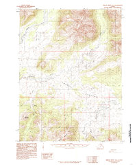
1985 Map of Ambler River A-2
USGS Topo · Published 1985About this map
Bornite serves as a primary point of reference in this northwestern Alaskan landscape, situated near the headwaters of several drainages. The area is defined by the meeting of high terrain and the broad Lowland, with Asbestos Mountain and Bannock Mountain rising above the river valleys. The hydrography is dominated by the Ambler River and the Shungnak River, which meander through the northern and central sections. A Tractor Trail provides a rare terrestrial transport route through the wilderness, connecting remote points across the drainage basins of Ruby Creek and Jay Creek. To the east, the Kogoluktuk River and its tributary Canyon Creek carve through the landscape, illustrating the complex drainage patterns characteristic of the Brooks Range foothills during the mid-1980s.
Find a feature on this map
16 named features on this map. Tap any name to fly to it.
Don’t see what you’re looking for? This feature index may not catch every label — zoom into the map to look around manually.
Map Details
Editions of this 1985 Ambler River A-2 Map
This is the sole edition of this map. No revisions or reprints were ever made.
Other maps of this area

1951 · Shungnak
USGS Topo · 1:250,000

1951 · Ambler River
USGS Topo · 1:250,000

1955 · Shungnak
USGS Topo · 1:250,000

1955 · Shungnak D-2
USGS Topo · 1:63,360

1955 · Shungnak D-3
USGS Topo · 1:63,360

1956 · Ambler River
USGS Topo · 1:250,000

1964 · Shungnak
USGS Topo · 1:250,000

1964 · Ambler River
USGS Topo · 1:250,000
1985 · Ambler River A-3
USGS Topo · 1:63,360
1985 · Shungnak D-1
USGS Topo · 1:63,360