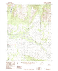
1985 Map of Shungnak D-1
USGS Topo · Published 1985About this map
The Kobuk River meanders across this northern landscape, its intricate oxbow loops and complex braiding defining the central valley as it appeared in the mid-1980s. This drainage network is fed by several major tributaries, including the Mauneluk River and the Killak River, which emerge from the surrounding upland terrain. In the northwestern corner, Kollioksak Lake stands as a prominent feature, its waters flowing into the Kolioksak River. Compiled from 1971 aerial photography, this provisional study shows a wilderness area devoid of established roads or permanent settlements, emphasizing the natural hydraulic systems of the Kunkcherk River and other waterways that have historically served as primary corridors through this part of the Northwest Arctic.
Find a feature on this map
6 named features on this map. Tap any name to fly to it.
Don’t see what you’re looking for? This feature index may not catch every label — zoom into the map to look around manually.
Map Details
Editions of this 1985 Shungnak D-1 Map
This is the sole edition of this map. No revisions or reprints were ever made.
Other maps of this area

1951 · Shungnak
USGS Topo · 1:250,000

1951 · Hughes
USGS Topo · 1:250,000

1951 · Survey Pass
USGS Topo · 1:250,000

1951 · Ambler River
USGS Topo · 1:250,000

1955 · Shungnak
USGS Topo · 1:250,000

1955 · Shungnak D-2
USGS Topo · 1:63,360

1956 · Hughes
USGS Topo · 1:250,000

1956 · Survey Pass
USGS Topo · 1:250,000

1956 · Ambler River
USGS Topo · 1:250,000

1964 · Survey Pass
USGS Topo · 1:250,000