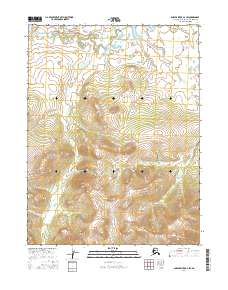
2016 Map of Ambler River A-2 SW
USGS Topo · Published 2016About this map
The mining settlement of Bornite sits on the western edge of the Cosmos Hills, positioned between the high peaks of Iron Mtn and Bannock Mtn. This northern Alaskan landscape is defined by a dense network of drainages that flow from these highlands toward the Shungnak River in the north. The area is marked by numerous watercourses including Ruby Cr, Jay Cr, and Dahl Cr, which illustrate the complex hydrology of the Northwest Arctic region.
Find a feature on this map
14 named features on this map. Tap any name to fly to it.
Don’t see what you’re looking for? This feature index may not catch every label — zoom into the map to look around manually.
Map Details
Editions of this 2016 Ambler River A-2 SW Map
This is the sole edition of this map. No revisions or reprints were ever made.
Other maps of this area

1951 · Shungnak
USGS Topo · 1:250,000

1951 · Ambler River
USGS Topo · 1:250,000

1955 · Shungnak
USGS Topo · 1:250,000

1955 · Shungnak D-2
USGS Topo · 1:63,360

1955 · Shungnak D-3
USGS Topo · 1:63,360

1956 · Ambler River
USGS Topo · 1:250,000

1964 · Shungnak
USGS Topo · 1:250,000

1964 · Ambler River
USGS Topo · 1:250,000
1985 · Ambler River A-3
USGS Topo · 1:63,360
1985 · Ambler River A-2
USGS Topo · 1:63,360