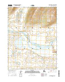
2016 Map of Ambler River A-3 NE
USGS Topo · Published 2016About this map
The Ambler River winds through this section of the Northwest Arctic borough, creating a complex network of braids and gravel bars across the low-lying terrain. The hydrography of the region is characterized by significant seasonal shifts, as seen in the wandering course of the river and its confluence with Naniratkohort Cr. To the north, the elevation rises sharply into a series of ridges, contrasting with the expansive wetlands and small bodies of water like Lake Anirak found in the southern reaches. This 2016 survey, produced with data from the Alaska Dept. of Transportation and other agencies, provides a clear view of the Public Land Survey System boundaries, including t21n r8e and t20n r8e, which define the administrative layout of this remote wilderness. The northern portion of the map is dominated by the drainage basin of Katurivik Cr, where the terrain begins its ascent away from the river valley.
Find a feature on this map
8 named features on this map. Tap any name to fly to it.
Don’t see what you’re looking for? This feature index may not catch every label — zoom into the map to look around manually.
Map Details
Editions of this 2016 Ambler River A-3 NE Map
This is the sole edition of this map. No revisions or reprints were ever made.
Other maps of this area

1951 · Ambler River
USGS Topo · 1:250,000

1956 · Ambler River
USGS Topo · 1:250,000

1964 · Ambler River
USGS Topo · 1:250,000
1985 · Ambler River A-3
USGS Topo · 1:63,360
1985 · Ambler River A-2
USGS Topo · 1:63,360
1990 · Ambler River B-3
USGS Topo · 1:63,360
1990 · Ambler River B-2
USGS Topo · 1:63,360
2015 · Ambler River B-3 SW
USGS Topo · 1:25,000
2015 · Ambler River A-3 NW
USGS Topo · 1:25,000
2016 · Ambler River B-2 SW
USGS Topo · 1:25,000