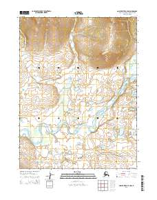
2015 Map of Ambler River A-3 NW
USGS Topo · Published 2015About this map
The Ambler River winds through this subarctic wilderness, creating a complex network of oxbow lakes and meandering side channels. Flowing from the hills to the north, the river is the central geographical feature of this interior landscape, joined by tributaries including Agnes Cr and Cross Cr. The terrain transitions from the high elevations in the northern sections, marked by steep contour intervals, down to a broad alluvial plain characterized by shifting watercourses. Lake Talhak sits in the southeastern portion of the sheet, likely an abandoned channel or kettle lake typical of this river system. This region, within the Northwest Arctic Borough, is defined by its remoteness and the absence of established road infrastructure, highlighting a landscape where natural drainage patterns and the seasonal flow of the Ambler River dictate travel and access.
Find a feature on this map
9 named features on this map. Tap any name to fly to it.
Don’t see what you’re looking for? This feature index may not catch every label — zoom into the map to look around manually.
Map Details
Editions of this 2015 Ambler River A-3 NW Map
This is the sole edition of this map. No revisions or reprints were ever made.
Other maps of this area

1951 · Ambler River
USGS Topo · 1:250,000

1955 · Ambler River A-4
USGS Topo · 1:63,360

1956 · Ambler River
USGS Topo · 1:250,000

1964 · Ambler River
USGS Topo · 1:250,000
1966 · Ambler River A-4
USGS Topo · 1:63,360
1985 · Ambler River A-3
USGS Topo · 1:63,360
1990 · Ambler River B-3
USGS Topo · 1:63,360
1990 · Ambler River B-4
USGS Topo · 1:63,360
2015 · Ambler River A-4 NE
USGS Topo · 1:25,000
2015 · Ambler River B-4 SE
USGS Topo · 1:25,000