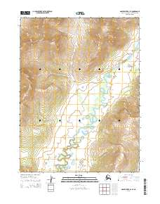
2015 Map of Ambler River B-4 SE
USGS Topo · Published 2015About this map
Redstone River meanders across the southern and eastern stretches of this remote landscape, defining the drainage patterns for the surrounding terrain. In the Northwest Arctic Borough, the water system is further fed by Akillyik Cr, which flows southward from the higher elevations of the northern townships. The topographic character of this 2015 study is dominated by the transition from steep, high-elevation ridges in the north to the broader river valley below. These waterways, including the smaller Aynes Cr in the southeast corner, remain the primary geographic anchors in a region largely defined by its natural hydrology and lack of built infrastructure. Surveyed by the U.S. Geological Survey, the map provides an exacting record of the township and range boundaries that organize this section of the Alaskan wilderness.
Find a feature on this map
9 named features on this map. Tap any name to fly to it.
Don’t see what you’re looking for? This feature index may not catch every label — zoom into the map to look around manually.
Map Details
Editions of this 2015 Ambler River B-4 SE Map
This is the sole edition of this map. No revisions or reprints were ever made.
Other maps of this area

1951 · Ambler River
USGS Topo · 1:250,000

1955 · Ambler River A-4
USGS Topo · 1:63,360

1956 · Ambler River
USGS Topo · 1:250,000

1964 · Ambler River
USGS Topo · 1:250,000
1966 · Ambler River A-4
USGS Topo · 1:63,360
1985 · Ambler River A-3
USGS Topo · 1:63,360
1990 · Ambler River B-3
USGS Topo · 1:63,360
1990 · Ambler River B-4
USGS Topo · 1:63,360
2015 · Ambler River B-4 SW
USGS Topo · 1:25,000
2015 · Ambler River A-4 NE
USGS Topo · 1:25,000