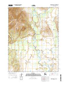
2015 Map of Ambler River B-6 SE
USGS Topo · Published 2015About this map
Kobuk Valley National Park encompasses a significant portion of this Arctic landscape, where the meandering Hunt River serves as the central hydrologic feature. The river’s complex oxbows and shifting channels define the low-lying basin, which is bordered by the more stable drainage of Nekakte Cr to the east and Akiak Cr in the northern reaches. This 2015 survey illustrates a vast wilderness area within the Alaska-Northwest Arctic Borough that remains largely devoid of permanent human infrastructure, focusing instead on the intricate topography and natural water systems. The absence of roads or settlements emphasizes the remote character of the region, where the primary landmarks are the named watercourses and the public land boundaries of the national park.
Find a feature on this map
10 named features on this map. Tap any name to fly to it.
Don’t see what you’re looking for? This feature index may not catch every label — zoom into the map to look around manually.
Map Details
Editions of this 2015 Ambler River B-6 SE Map
This is the sole edition of this map. No revisions or reprints were ever made.
Other maps of this area

1951 · Ambler River
USGS Topo · 1:250,000

1955 · Ambler River A-6
USGS Topo · 1:63,360

1955 · Ambler River A-5
USGS Topo · 1:63,360

1956 · Ambler River
USGS Topo · 1:250,000

1964 · Ambler River
USGS Topo · 1:250,000
1990 · Ambler River B-5
USGS Topo · 1:63,360
1990 · Ambler River B-6
USGS Topo · 1:63,360
2015 · Ambler River B-5 NW
USGS Topo · 1:25,000
2015 · Ambler River A-5 NW
USGS Topo · 1:25,000
2015 · Ambler River B-6 NE
USGS Topo · 1:25,000