
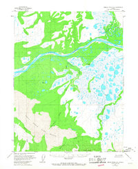
1955 Map of Ambler River A-6
USGS Topo · Published 1959About this map
The Great Kobuk Sand Dunes dominate the southern portion of this landscape, presenting a striking contrast to the surrounding Arctic hydrology. This 1950s survey captures a complex network of waterways, centered on the broad Kobuk River as it winds through a basin filled with numerous unnamed ponds and wetlands. The intricate drainage patterns are defined by the Ahnewetut Creek, which flows from the dunes toward the Ahnewetut Lake, and the Akillik River further north. Survey control points like Vabm 471 Hunt and Vabm 95 Vega mark the topographic elevations that rise toward the Waring Mountains in the south, illustrating the transition from shifting sands and marshland to the more stable mountainous terrain of Northwest Alaska.
Find a feature on this map
11 named features on this map. Tap any name to fly to it.
Don’t see what you’re looking for? This feature index may not catch every label — zoom into the map to look around manually.
Map Details
Editions of this 1955 Ambler River A-6 Map
2 editions found
Other maps of this area

1951 · Baird Mountains
USGS Topo · 1:250,000

1951 · Selawik
USGS Topo · 1:250,000

1951 · Shungnak
USGS Topo · 1:250,000

1951 · Ambler River
USGS Topo · 1:250,000

1955 · Shungnak
USGS Topo · 1:250,000

1955 · Baird Mountains A-1
USGS Topo · 1:63,360

1955 · Shungnak D-6
USGS Topo · 1:63,360

1955 · Shungnak D-5
USGS Topo · 1:63,360
1955 · Selawik D-1
USGS Topo · 1:63,360

1955 · Ambler River A-5
USGS Topo · 1:63,360