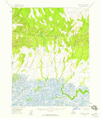
1955 Map of Selawik D-1
USGS Topo · Published 1959About this map
Waring Mountains dominate the northern terrain of this mid-century survey, giving way to a vast, water-rich basin in the south. The landscape is defined by the drainage patterns of the Nuleargowik River and the Ikagvik River, which wind through an intricate network of wetlands and small lakes. Based on aerial photography from 1955 and 1957, this map illustrates the complex hydrology of the Arctic wilderness before significant modern infrastructure reached this part of the Northwest Arctic region. The lack of roads or established trails highlights the reliance on these river corridors for navigation and subsistence. The transition from the high ridges of the mountains to the saturated lowlands provides a clear view of the geographic barriers that have shaped movement and land use throughout the era.
Find a feature on this map
3 named features on this map. Tap any name to fly to it.
Don’t see what you’re looking for? This feature index may not catch every label — zoom into the map to look around manually.
Map Details
Editions of this 1955 Selawik D-1 Map
2 editions found
Other maps of this area

1951 · Baird Mountains
USGS Topo · 1:250,000

1951 · Selawik
USGS Topo · 1:250,000

1951 · Shungnak
USGS Topo · 1:250,000

1951 · Ambler River
USGS Topo · 1:250,000

1955 · Shungnak
USGS Topo · 1:250,000

1955 · Baird Mountains A-1
USGS Topo · 1:63,360

1955 · Selawik D-2
USGS Topo · 1:63,360

1955 · Ambler River A-6
USGS Topo · 1:63,360

1955 · Shungnak D-6
USGS Topo · 1:63,360

1955 · Baird Mountains A-2
USGS Topo · 1:63,360