
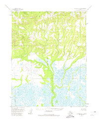
1955 Map of Shungnak D-6
USGS Topo · Published 1959About this map
The Waring Mountains dominate the northern skyline of this mid-century survey, yielding to a complex network of wetlands and river systems as the elevation drops toward the south. The Kogoluktuk River serves as the primary drainage for this remote landscape, carving a path through the terrain where it is joined by the Niaktuvik Creek. Surveyors from the era identified critical high-ground markers for navigation and mapping, including VABM 1269 Sandview and VABM 426 Nulik, which stand as prominent landmarks in an otherwise roadless territory. The transition from the high ridges of the northern mountains to the marshy flats below illustrates the drainage patterns characteristic of the Northwest Arctic region, captured here during the 1955 field annotation period.
Find a feature on this map
5 named features on this map. Tap any name to fly to it.
Don’t see what you’re looking for? This feature index may not catch every label — zoom into the map to look around manually.
Map Details
Editions of this 1955 Shungnak D-6 Map
2 editions found
Other maps of this area

1951 · Baird Mountains
USGS Topo · 1:250,000

1951 · Selawik
USGS Topo · 1:250,000

1951 · Shungnak
USGS Topo · 1:250,000

1951 · Ambler River
USGS Topo · 1:250,000

1955 · Shungnak
USGS Topo · 1:250,000

1955 · Baird Mountains A-1
USGS Topo · 1:63,360

1955 · Ambler River A-6
USGS Topo · 1:63,360

1955 · Shungnak D-5
USGS Topo · 1:63,360
1955 · Selawik D-1
USGS Topo · 1:63,360

1955 · Ambler River A-5
USGS Topo · 1:63,360