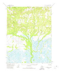
1955 Map of Shungnak D-6
USGS Topo · Published 1974About this map
The Waring Mountains dominate the northern landscape of this mid-century survey, rising above a vast network of wetlands and tundra drainage. This 1955 aerial-photogrammetric study reveals a wilderness devoid of roads or trails, where the land is defined by the shifting paths of Kavel Creek and the meandering Kuchuk Creek. The map serves as a primary record of the terrain along the Kateel River Meridian, marking high points like Vabm 1265 Sandview and Vabm 425 Nulv. These triangulation stations represent the early efforts of the Geological Survey to systematically plot this remote Alaskan interior. The drainage patterns of Niaktuvik Creek flowing into the lower marshlands illustrate a landscape largely shaped by seasonal water movement and the physical barrier of the northern range.
Find a feature on this map
7 named features on this map. Tap any name to fly to it.
Don’t see what you’re looking for? This feature index may not catch every label — zoom into the map to look around manually.
Map Details
Editions of this 1955 Shungnak D-6 Map
2 editions found
Other maps of this area

1951 · Baird Mountains
USGS Topo · 1:250,000

1951 · Selawik
USGS Topo · 1:250,000

1951 · Shungnak
USGS Topo · 1:250,000

1951 · Ambler River
USGS Topo · 1:250,000

1955 · Shungnak
USGS Topo · 1:250,000

1955 · Baird Mountains A-1
USGS Topo · 1:63,360

1955 · Ambler River A-6
USGS Topo · 1:63,360

1955 · Shungnak D-6
USGS Topo · 1:63,360

1955 · Shungnak D-5
USGS Topo · 1:63,360
1955 · Selawik D-1
USGS Topo · 1:63,360