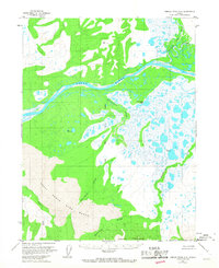
1955 Map of Ambler River A-6
USGS Topo · Published 1967About this map
The Great Kobuk Sand Dunes dominate the southern landscape of this mid-century survey, revealing a striking geological anomaly where massive dunes are bounded by the Kobuk River to the north and the Waring Mountains to the south. This area is defined by its complex drainage network, where the Akillik River and Hunt River join the primary Kobuk waterway amid a landscape saturated with ponds and wetlands. The mapping of the Kateel River Principal Meridian through this territory reflects the systematic effort to survey these interior reaches of the Northwest Arctic during the 1950s. The presence of Ahnewetut Lake and the meandering Niaktuvik Creek illustrate a wilderness where water and wind-blown sand are the primary architects of the terrain, entirely devoid of roads or permanent settlements at the time of the 1955 field annotation.
Find a feature on this map
10 named features on this map. Tap any name to fly to it.
Don’t see what you’re looking for? This feature index may not catch every label — zoom into the map to look around manually.
Map Details
Editions of this 1955 Ambler River A-6 Map
2 editions found
Other maps of this area

1951 · Baird Mountains
USGS Topo · 1:250,000

1951 · Selawik
USGS Topo · 1:250,000

1951 · Shungnak
USGS Topo · 1:250,000

1951 · Ambler River
USGS Topo · 1:250,000

1955 · Shungnak
USGS Topo · 1:250,000

1955 · Baird Mountains A-1
USGS Topo · 1:63,360

1955 · Ambler River A-6
USGS Topo · 1:63,360

1955 · Shungnak D-6
USGS Topo · 1:63,360

1955 · Shungnak D-5
USGS Topo · 1:63,360
1955 · Selawik D-1
USGS Topo · 1:63,360