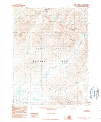
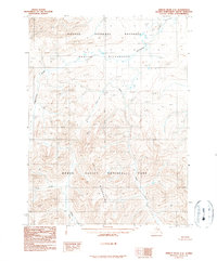
1990 Map of Ambler River B-5
USGS Topo · Published 1990About this map
The Jade Mountains rise in the southern reaches of this Northwest Arctic landscape, a region defined by its vast protected wilderness and lack of industrial development. Photographed in the late 1970s and edited in 1990, the map illustrates the expansive boundaries of Kobuk Valley National Park, which dominates the central and southern portions of the sheet. In the north, the map edges into the Noatak Nat Pres (Noatak Wilderness), showing a territory where natural drainage systems like the Akillik River dictate the geography. Braided watercourses and seasonal flows characterize the lowlands between the peaks, where Nekakte Creek and Nuna Creek wind through the tundra. This provisional survey provides a precise view of the topography before modern satellite updates, focusing on the literal lay of the land where no roads or permanent settlements are indicated.
Find a feature on this map
7 named features on this map. Tap any name to fly to it.
Don’t see what you’re looking for? This feature index may not catch every label — zoom into the map to look around manually.
Map Details
Editions of this 1990 Ambler River B-5 Map
This is the sole edition of this map. No revisions or reprints were ever made.
Other maps of this area

1951 · Ambler River
USGS Topo · 1:250,000

1955 · Ambler River A-4
USGS Topo · 1:63,360

1955 · Ambler River A-6
USGS Topo · 1:63,360

1955 · Ambler River A-5
USGS Topo · 1:63,360

1956 · Ambler River
USGS Topo · 1:250,000

1964 · Ambler River
USGS Topo · 1:250,000
1966 · Ambler River A-4
USGS Topo · 1:63,360
1990 · Ambler River B-6
USGS Topo · 1:63,360
1990 · Ambler River B-4
USGS Topo · 1:63,360
1990 · Ambler River C-6
USGS Topo · 1:63,360