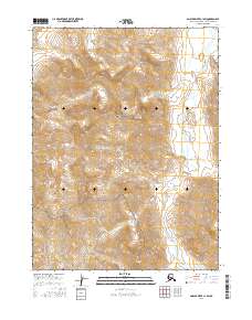
2016 Map of Ambler River C-1 SW
USGS Topo · Published 2016About this map
Gates Of The Arctic National Park encompasses the majority of this Alaskan wilderness, where the high ridges of the Brooks Range drop toward the river valleys. The topography is defined by significant elevations, including the prominent peak of Blind Pass Mtn, which stands as a landmark in the southern portion of the quadrangle. Drainage patterns are shaped by several major waterways that cut through the mountain passes and tundra, most notably the Ipneivik River as it flows south through the eastern half of the sheet.
Find a feature on this map
11 named features on this map. Tap any name to fly to it.
Don’t see what you’re looking for? This feature index may not catch every label — zoom into the map to look around manually.
Map Details
Editions of this 2016 Ambler River C-1 SW Map
This is the sole edition of this map. No revisions or reprints were ever made.
Other maps of this area

1951 · Ambler River
USGS Topo · 1:250,000

1956 · Ambler River
USGS Topo · 1:250,000

1964 · Ambler River
USGS Topo · 1:250,000
1990 · Ambler River C-1
USGS Topo · 1:63,360
1990 · Ambler River B-1
USGS Topo · 1:63,360
1990 · Ambler River B-2
USGS Topo · 1:63,360
1990 · Ambler River C-2
USGS Topo · 1:63,360
2016 · Ambler River C-1 NW
USGS Topo · 1:25,000
2016 · Ambler River B-1 NW
USGS Topo · 1:25,000
2016 · Ambler River C-2 NE
USGS Topo · 1:25,000