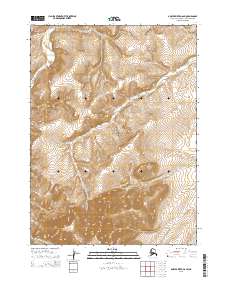
2015 Map of Ambler River D-6 SW
USGS Topo · Published 2015About this map
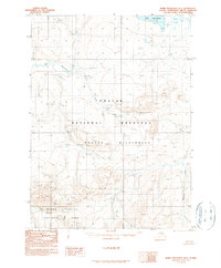
The Noatak National Preserve encompasses the vast majority of this 2015 survey, protecting an arctic wilderness defined by the winding paths of Namielik Creek and Kunyanak Cr. Located in the Northwest Arctic Borough of Alaska, the landscape is almost entirely undeveloped, showing a high-resolution view of drainage patterns and high-latitude topography. Unlike earlier maps of the region, this 2015 update utilizes data from the National Elevation Dataset and National Hydrography Dataset to precisely chart the headwaters and tributaries that feed the larger Ambler River system. The map is primarily an administrative and topographic study, focused on the public land boundaries of the Preserve across townships like t28n r1w and t27n r1w, offering a clear look at the terrain before any modern human encroachment or permanent infrastructure.
Find a feature on this map
11 named features on this map. Tap any name to fly to it.
Don’t see what you’re looking for? This feature index may not catch every label — zoom into the map to look around manually.
Map Details
Editions of this 2015 Ambler River D-6 SW Map
This is the sole edition of this map. No revisions or reprints were ever made.
Other maps of this area

1951 · Baird Mountains
USGS Topo · 1:250,000

1951 · Ambler River
USGS Topo · 1:250,000

1956 · Ambler River
USGS Topo · 1:250,000

1956 · Baird Mountains
USGS Topo · 1:250,000

1964 · Ambler River
USGS Topo · 1:250,000

1965 · Baird Mountains
USGS Topo · 1:250,000
1990 · Ambler River D-6
USGS Topo · 1:63,360
1990 · Baird Mountains C-1
USGS Topo · 1:63,360
1990 · Ambler River C-6
USGS Topo · 1:63,360
1990 · Baird Mountains D-1
USGS Topo · 1:63,360