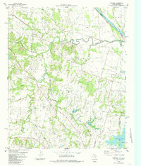
1984 Map of Ambrose
USGS Topo · Published 1985About this map
The Red River marks the northern boundary of this North Texas landscape, where the meandering course of Choctaw Creek and its many tributaries, including Mill Creek and Jack Branch, carve through the terrain of Grayson Co and Fannin Co. The community of Ambrose and the settlement at South Gale anchor the local geography, surrounded by a network of family-named landmarks and rural landmarks. Genealogists will find a wealth of burial sites, from Cherry Mound Cem and Dugan Cem to Virginia Point Cem and Bush Cem. Transportation history is evident in the path of the Missouri Kansas Texas railroad and an Old Railroad Grade that speaks to earlier transit routes. In the southeast, the waters of Valley Lake indicate the impact of modern water management on this traditionally agrarian region.
Find a feature on this map
32 named features on this map. Tap any name to fly to it.
Don’t see what you’re looking for? This feature index may not catch every label — zoom into the map to look around manually.
Map Details
Editions of this 1984 Ambrose Map
This is the sole edition of this map. No revisions or reprints were ever made.
Other maps of this area

1901 · Denison
USGS Topo · 1:125,000

1954 · Sherman
USGS Topo · 1:250,000

1957 · Denison Dam
USGS Topo · 1:24,000

1958 · Durant
USGS Topo · 1:62,500

1958 · Whitesright
USGS Topo · 1:62,500

1958 · Denison Dam
USGS Topo · 1:62,500

1958 · Sherman
USGS Topo · 1:250,000

1958 · Sherman
USGS Topo · 1:62,500

1958 · Sherman
USGS Topo · 1:24,000

1958 · Howe
USGS Topo · 1:24,000