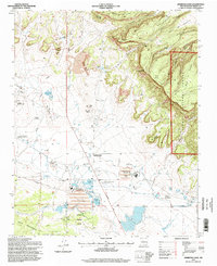
1995 Map of Ambrosia Lake
USGS Topo · Published 1998About this map
The industrial infrastructure of the Grants uranium district is deeply etched into the landscape of this mid-1990s survey. Heavy industry dominates the basin south of Ambrosia Lake, where the Kermac Nuclear Fuels Processing Plant and the Philips Petroleum Ambrosia Mill sit surrounded by extensive Tailings Ponds and water Storage Ponds. This network of uranium extraction is evidenced by numerous shafts, including the Homestake Sapin Mine No 23, Ann Lee Mine No 1, and the United Western Mine, many connected by a web of service roads and the prominent Ambrosia Lake Road.
Find a feature on this map
62 named features on this map. Tap any name to fly to it.
Don’t see what you’re looking for? This feature index may not catch every label — zoom into the map to look around manually.
Map Details
Editions of this 1995 Ambrosia Lake Map
This is the sole edition of this map. No revisions or reprints were ever made.
Other maps of this area

1883 · Mt. Taylor
USGS Topo · 1:250,000

1886 · Mt. Taylor
USGS Topo · 1:250,000

1892 · Mt. Taylor
USGS Topo · 1:250,000

1899 · Mt. Taylor
USGS Topo · 1:250,000

1957 · Ambrosia Lake
USGS Topo · 1:24,000

1957 · Dos Lomas
USGS Topo · 1:24,000

1957 · Bluewater
USGS Topo · 1:24,000

1957 · Goat Mountain
USGS Topo · 1:24,000

1958 · Albuquerque
USGS Topo · 1:250,000

1961 · Piedra De La Aguila
USGS Topo · 1:24,000