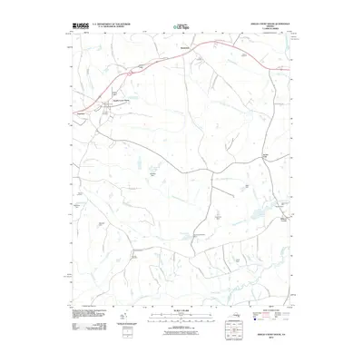
2010 Map of Amelia Court House
USGS Topo · Published 2010About this map
Amelia Court House serves as the focal point of this Virginia interior landscape, where the confluence of local roads like Virginia St and Amelia Ave reveals the historic core of the county seat. The surrounding countryside is defined by an intricate network of waterways and mill sites, including the Beaverpond Mill and Beaver Dam situated along Beaverpond Creek. These features point to a long history of water-powered industry and local agriculture that shaped the development of the region.
Find a feature on this map
66 named features on this map. Tap any name to fly to it.
Don’t see what you’re looking for? This feature index may not catch every label — zoom into the map to look around manually.
Map Details
Editions of this 2010 Amelia Court House Map
This is the sole edition of this map. No revisions or reprints were ever made.
Other maps of this area

1891 · Farmville
USGS Topo · 1:125,000

1893 · Farmville
USGS Topo · 1:125,000

1897 · Amelia
USGS Topo · 1:125,000

1943 · Amelia
USGS Topo · 1:31,680

1943 · Goodes Bridge
USGS Topo · 1:31,680

1943 · Clayville
USGS Topo · 1:24,000
1943 · Chula
USGS Topo · 1:24,000

1943 · Richmond
USGS Topo · 1:250,000

1944 · Chula
USGS Topo · 1:31,680
1944 · Clayville
USGS Topo · 1:31,680