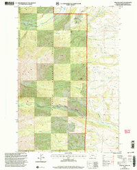
2000 Map of Amelong Creek
USGS Topo · Published 2005About this map
Gallatin National Forest dominates this Montana landscape, where the Big Timber Ranger District manages a complex watershed of high-altitude drainages. At the turn of the millennium, this area preserved a rugged wilderness character, defined by the descent of Sweet Grass Creek and the dramatic topographic relief of Big Timber Canyon. The map reveals the intricate network of the Amelong drainage, split between North Amelong Creek and South Amelong Creek, which converge as they flow toward the eastern plains. Notable landmarks like the prominent Black Butte and the Half Moon area provide reference points for those navigating the backcountry. Human influence is sparse, primarily seen in engineering like the Stocker Ditch and the trails leading toward Upper Big Timber Falls, reflecting a region dedicated to conservation and seasonal grazing rather than permanent settlement.
Find a feature on this map
26 named features on this map. Tap any name to fly to it.
Don’t see what you’re looking for? This feature index may not catch every label — zoom into the map to look around manually.
Map Details
Editions of this 2000 Amelong Creek Map
This is the sole edition of this map. No revisions or reprints were ever made.
Other maps of this area

1886 · Little Belt Mts.
USGS Topo · 1:250,000

1891 · Livingston
USGS Topo · 1:250,000

1893 · Livingston
USGS Topo · 1:250,000

1894 · Little Belt Mts.
USGS Topo · 1:250,000

1897 · Little Belt Mts.
USGS Topo · 1:250,000

1898 · Little Belt Mts.
USGS Topo · 1:250,000

1902 · Little Belt Mts.
USGS Topo · 1:250,000

1947 · Bozeman
USGS Topo · 1:250,000

1948 · Bozeman
USGS Topo · 1:250,000

1948 · White Sulphur Springs
USGS Topo · 1:250,000