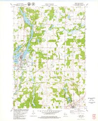
1978 Map of Amery
USGS Topo · Published 1979About this map
The Apple River winds south through Polk County, defining the growth of Amery as it flows past the Amery Corp Bdy. In the late 1970s, this landscape is a dense network of glacial lakes and wetlands, where water bodies like Pike Lake, North Twin Lake, and Lincoln Lake alternate with pockets of timber and agricultural land. The transition from industrial extraction to recreation is evident in the numerous Gravel Pits and Sandpits scattered near the river, while the Snake Creek State Snake Public Fishing Area and Clear Lake Village Park highlight the region's conservation value. Local civic life is anchored by landmarks such as the Apple River Ch, East Lincoln Ch, and several rural schools. To the southeast, the village of Clear Lake sits beside its namesake water, featuring a localized cluster of homes and a Trailer Park.
Find a feature on this map
44 named features on this map. Tap any name to fly to it.
Don’t see what you’re looking for? This feature index may not catch every label — zoom into the map to look around manually.
Map Details
Editions of this 1978 Amery Map
This is the sole edition of this map. No revisions or reprints were ever made.
Other maps of this area

1948 · Downing
USGS Topo · 1:62,500

1950 · Downing
USGS Topo · 1:62,500

1950 · Deer Park
USGS Topo · 1:62,500

1950 · Balsam Lake
USGS Topo · 1:62,500

1950 · Turtle Lake
USGS Topo · 1:62,500

1952 · Turtle Lake
USGS Topo · 1:62,500

1953 · Stillwater
USGS Topo · 1:250,000

1955 · Stillwater
USGS Topo · 1:250,000

1958 · Stillwater
USGS Topo · 1:250,000

1965 · Stillwater
USGS Topo · 1:250,000