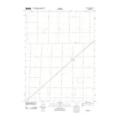
2010 Map of Amherst
USGS Topo · Published 2010About this map
Amherst serves as the central hub of this agricultural landscape in Phillips County, defined by a strictly organized grid of county roads and the diagonal path of a regional highway. The town's modest footprint is complemented by the Amherst Cemetery located to the north, reflecting the long-term settlement patterns of this high plains community. Meandering across the southern portion of the quadrangle, Wildhorse Creek introduces the only significant natural variation in a terrain otherwise dominated by precise rectangular survey lines. This 2010 survey illustrates the persistence of rural infrastructure, where routes such as County Rd 2 and County Rd 55 create a network of section lines that support the local farming economy.
Find a feature on this map
19 named features on this map. Tap any name to fly to it.
Don’t see what you’re looking for? This feature index may not catch every label — zoom into the map to look around manually.
Map Details
Editions of this 2010 Amherst Map
This is the sole edition of this map. No revisions or reprints were ever made.
Other maps of this area

1952 · Julesburg SE
USGS Topo · 1:24,000

1954 · Sterling
USGS Topo · 1:250,000

1958 · Sterling
USGS Topo · 1:250,000

1962 · Venango SW
USGS Topo · 1:24,000

1962 · Holyoke NE
USGS Topo · 1:24,000

1962 · Amherst
USGS Topo · 1:24,000

1962 · Amherst NE
USGS Topo · 1:24,000
1962 · Venango
USGS Topo · 1:24,000

1971 · Amherst SW
USGS Topo · 1:24,000

1971 · Holyoke
USGS Topo · 1:24,000