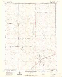
1962 Map of Venango
USGS Topo · Published 1964About this map
The borderlands of the Colorado-Nebraska state line define this high-plains landscape, where the town of Venango serves as a small rail hub along the Chicago Burlington and railroad. Located in Perkins County, the settlement is compactly organized around local amenities including an Athletic Field, Ball Park, and a prominent Water Tank near the tracks. The surrounding terrain is marked by rolling dunes and intermittent drainage features, most notably Sand Creek, which winds through the southern portion of the quadrangle. Transportation and aviation interests of the early 1960s are evident in the presence of the Dudden Landing Strip and the Quincy road. This survey captures a moment when rural infrastructure, from the local Gravel Pit to the precise section line boundaries of Sedgwick and Perkins Counties, reflects a deeply surveyed and agricultural landscape.
Find a feature on this map
13 named features on this map. Tap any name to fly to it.
Don’t see what you’re looking for? This feature index may not catch every label — zoom into the map to look around manually.
Map Details
Editions of this 1962 Venango Map
This is the sole edition of this map. No revisions or reprints were ever made.
Other maps of this area

1954 · Sterling
USGS Topo · 1:250,000

1954 · McCook
USGS Topo · 1:250,000

1957 · McCook
USGS Topo · 1:250,000

1958 · McCook
USGS Topo · 1:250,000

1958 · Sterling
USGS Topo · 1:250,000

1961 · Brandon NW
USGS Topo · 1:24,000

1961 · Lamar NW
USGS Topo · 1:24,000

1961 · Brandon
USGS Topo · 1:24,000

1962 · Venango SW
USGS Topo · 1:24,000
1962 · Venango NE
USGS Topo · 1:24,000