
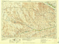
1958 Map of McCook
USGS Topo · Published 1958About this map
The Republican River and Frenchman River valleys anchor this 1950s study of southwest Nebraska, where the arid Sand Hills meet the fertile irrigated plains of the Platte watershed. This landscape is defined by its water management systems, including the substantial Swanson Lake and Medicine Creek Reservoir, which supported the region's agricultural transition. The city of McCook serves as a primary hub for the Chicago Burlington and Quincy RR, while smaller cattle and grain towns like Imperial and Hayes Center dot the upland plateaus. For local historians, the map captures specific landmarks of rural life, such as St Johns Church and the numerous grain elevators that stood along the rail sidings of the Union Pacific RR. The network of irrigation infrastructure is particularly visible in the northeast, where the Gothenburg Canal and Orchard Alfalfa Canal divert from the Platte River.
Find a feature on this map
81 named features on this map. Tap any name to fly to it.
Don’t see what you’re looking for? This feature index may not catch every label — zoom into the map to look around manually.
Map Details
Editions of this 1958 McCook Map
2 editions found
Other maps of this area

1893 · Norton
USGS Topo · 1:125,000

1896 · Lexington
USGS Topo · 1:125,000

1896 · Arapahoe
USGS Topo · 1:125,000

1897 · Ogallala
USGS Topo · 1:125,000

1898 · Arapahoe
USGS Topo · 1:125,000

1898 · Paxton
USGS Topo · 1:125,000

1899 · Lexington
USGS Topo · 1:125,000

1899 · North Platte
USGS Topo · 1:125,000

1900 · Chappell
USGS Topo · 1:125,000

1900 · Ogallala
USGS Topo · 1:125,000