1957 Map of McCook
USGS Topo · Published 1957About this map
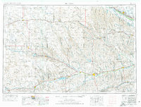
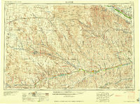
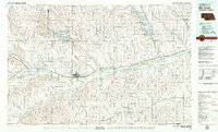
The Republican River and Platte River valley systems define this mid-1950s landscape across southwestern Nebraska and northern Kansas. This survey details a transition from the rolling Sand Hills in the north to the more structured irrigation and rail corridors along the major river ways. The Chicago Burlington and Quincy railroad follows the Republican drainage, connecting towns like Culbertson, McCook, and Arapahoe. Significant water management features of the post-war era are prominent, including the Medicine Creek Reservoir and the large Swanson Lake near Trenton. To the north, the Union Pacific line runs parallel to the Platte, passing through Gothenburg and Cozad, where the Thirty Mile Canal and Willow Island Canal support the region's agricultural infrastructure. Smaller communities like Wellfleet, Wauneta, and Wallace dot the landscape, often situated near vital water sources like Stinking Water Creek or Frenchman River.
Find a feature on this map
88 named features on this map. Tap any name to fly to it.
Don’t see what you’re looking for? This feature index may not catch every label — zoom into the map to look around manually.
Map Details
Editions of this 1957 McCook Map
This is the sole edition of this map. No revisions or reprints were ever made.
Historical Maps of McCook Through Time
4 maps found