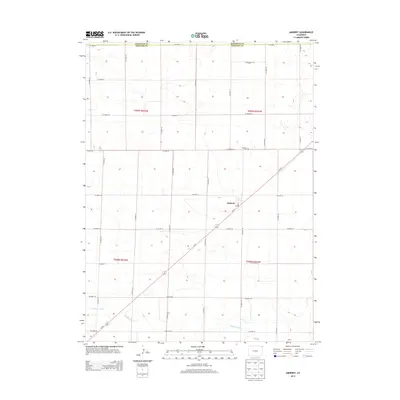
2013 Map of Amherst
USGS Topo · Published 2013About this map
The settlement of Amherst serves as the focal point for this survey of northeastern Colorado, where the high plains landscape is defined by a rigid section-line grid of county roads. The community's local infrastructure is clearly marked, including the Po and the nearby Amherst Cem. Natural drainage is provided by the winding course of Wildhorse Creek, which cuts across the southern townships in contrast to the geometric precision of the surrounding agricultural land. Bisecting the region diagonally from the southwest to the northeast is Co-23, the primary transportation artery connecting these rural sections. The map also delineates the jurisdictional boundary between Sedgwick Co and Phillips Co, illustrating how early twentieth-century land divisions continue to shape the modern geography of the region.
Find a feature on this map
27 named features on this map. Tap any name to fly to it.
Don’t see what you’re looking for? This feature index may not catch every label — zoom into the map to look around manually.
Map Details
Editions of this 2013 Amherst Map
This is the sole edition of this map. No revisions or reprints were ever made.
Other maps of this area

1952 · Julesburg SE
USGS Topo · 1:24,000

1954 · Sterling
USGS Topo · 1:250,000

1958 · Sterling
USGS Topo · 1:250,000

1962 · Venango SW
USGS Topo · 1:24,000

1962 · Holyoke NE
USGS Topo · 1:24,000

1962 · Amherst
USGS Topo · 1:24,000

1962 · Amherst NE
USGS Topo · 1:24,000
1962 · Venango
USGS Topo · 1:24,000

1971 · Amherst SW
USGS Topo · 1:24,000

1971 · Holyoke
USGS Topo · 1:24,000