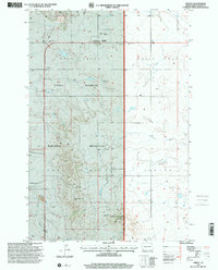
1997 Map of Amidon
USGS Topo · Published 2001About this map
Amidon stands as the primary settlement in this section of Slope County, serving as a gateway to the diverse geography of the Little Missouri National Grassland. The landscape is dominated by notable geological rises, most significantly White Butte, which reaches the highest elevation in North Dakota. This 1997 revision by the U.S. Department of Agriculture Forest Service details a ranching and rural landscape defined by wide drainages like Sand Creek and the high flats of White Lake. Local history is anchored by sites such as the County Fairground and the Lebanon Cem and St Peter and Paul Cem, which reflect the community's early 20th-century foundations. The map illustrates a shift toward modern infrastructure with the inclusion of a Communication Site and Davis ET alongside traditional features like cattle tanks and scattered gravel pits.
Find a feature on this map
19 named features on this map. Tap any name to fly to it.
Don’t see what you’re looking for? This feature index may not catch every label — zoom into the map to look around manually.
Map Details
Editions of this 1997 Amidon Map
This is the sole edition of this map. No revisions or reprints were ever made.
Other maps of this area

1953 · Dickinson
USGS Topo · 1:250,000

1957 · Dickinson
USGS Topo · 1:250,000

1961 · Daglum
USGS Topo · 1:62,500

1961 · Rocky Ridge
USGS Topo · 1:62,500

1973 · Black Butte
USGS Topo · 1:24,000

1973 · White Lake
USGS Topo · 1:24,000

1973 · Mineral Springs
USGS Topo · 1:24,000

1973 · Amidon SE
USGS Topo · 1:24,000

1973 · Stewart Lake
USGS Topo · 1:24,000

1973 · Amidon
USGS Topo · 1:24,000