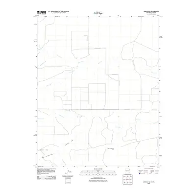
2010 Map of Amistad SE
USGS Topo · Published 2010About this map
Centerville sits at the heart of this high plains landscape on the border of New Mexico and Texas. The 2010 geography is defined by a sparse network of ranching roads and a series of ephemeral drainages that carve through the dry terrain. Significant watercourses like Monia Creek and Cramer Creek dominate the drainage patterns, flowing toward the east and south across a wide, open plateau. To the south, the prominent rise of High Lonesome Hill provides a distinct landmark amidst the intersecting paths of Fullingim Draw and South Fullingim Draw. The map details a transition from the structured grid of County Hwy C-097 and County Hwy C-099 to the more winding paths of Ranch Road 3296, illustrating the remote nature of these borderland ranching communities.
Find a feature on this map
12 named features on this map. Tap any name to fly to it.
Don’t see what you’re looking for? This feature index may not catch every label — zoom into the map to look around manually.
Map Details
Editions of this 2010 Amistad SE Map
This is the sole edition of this map. No revisions or reprints were ever made.
Other maps of this area

1954 · Tucumcari
USGS Topo · 1:250,000

1958 · Tucumcari
USGS Topo · 1:250,000

1971 · Kerlin Hill
USGS Topo · 1:24,000

1971 · Koger Ranch
USGS Topo · 1:24,000

1971 · Centerville Corner
USGS Topo · 1:24,000

1971 · Doyle Hill
USGS Topo · 1:24,000

1971 · Amistad SE
USGS Topo · 1:24,000

1971 · Beck Ranch
USGS Topo · 1:24,000
1971 · Amistad
USGS Topo · 1:24,000

1971 · Whiteaker Ranch
USGS Topo · 1:24,000