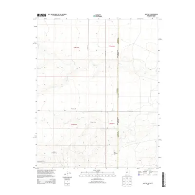
2013 Map of Amistad SE
USGS Topo · Published 2013About this map
Centerville sits at the junction of NM-417 and CO Highway C-097 in this high plains landscape straddling the New Mexico-Texas border. The terrain is defined by a series of intermittent watercourses and draws that drain the prairie, including the winding paths of Monia Cr and Cramer Cr. To the south, the land rises toward the distinct elevation of High Lonesome Hill, overlooking the broad depressions of Fullingim Draw and South Fullingim Draw. The map illustrates the sparsely populated ranching country where Union and Hartley Counties meet, showing the transition from New Mexico state routes to Texas farm-to-market style roads like Ranch Road 3296. Local history researchers will find the grid of the Public Land Survey System clearly marked, providing a framework for tracing property lines across this rural borderland.
Find a feature on this map
19 named features on this map. Tap any name to fly to it.
Don’t see what you’re looking for? This feature index may not catch every label — zoom into the map to look around manually.
Map Details
Editions of this 2013 Amistad SE Map
This is the sole edition of this map. No revisions or reprints were ever made.
Other maps of this area

1954 · Tucumcari
USGS Topo · 1:250,000

1958 · Tucumcari
USGS Topo · 1:250,000

1971 · Kerlin Hill
USGS Topo · 1:24,000

1971 · Koger Ranch
USGS Topo · 1:24,000

1971 · Centerville Corner
USGS Topo · 1:24,000

1971 · Doyle Hill
USGS Topo · 1:24,000

1971 · Amistad SE
USGS Topo · 1:24,000

1971 · Beck Ranch
USGS Topo · 1:24,000
1971 · Amistad
USGS Topo · 1:24,000

1971 · Whiteaker Ranch
USGS Topo · 1:24,000