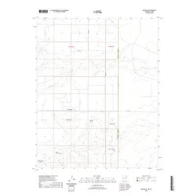
2020 Map of Amistad SE
USGS Topo · Published 2020About this map
Centerville sits at a high-plains crossroads in Union County, where the topography is defined by a series of drainages cutting eastward toward the state line. This landscape, as it appeared in 2020, is part of the High Plains transition where New Mexico and Texas meet. The terrain is marked by seasonal watercourses like Monia Cr and Cramer Cr, which reveal the erosive patterns typical of this semi-arid ranching country. The map provides a look at the modern rural infrastructure, where routes such as Romero Rd and Ranch Rd 3296 connect isolated homesteads and grazing lands. Rising above the draws, High Lonesome Hill serves as a prominent local landmark, while the complex hydrology of Fullingim Draw and South Fullingim Draw illustrates the natural drainage network of the Amistad SE area.
Find a feature on this map
17 named features on this map. Tap any name to fly to it.
Don’t see what you’re looking for? This feature index may not catch every label — zoom into the map to look around manually.
Map Details
Editions of this 2020 Amistad SE Map
This is the sole edition of this map. No revisions or reprints were ever made.
Other maps of this area

1954 · Tucumcari
USGS Topo · 1:250,000

1958 · Tucumcari
USGS Topo · 1:250,000

1971 · Kerlin Hill
USGS Topo · 1:24,000

1971 · Koger Ranch
USGS Topo · 1:24,000

1971 · Centerville Corner
USGS Topo · 1:24,000

1971 · Doyle Hill
USGS Topo · 1:24,000

1971 · Amistad SE
USGS Topo · 1:24,000

1971 · Beck Ranch
USGS Topo · 1:24,000
1971 · Amistad
USGS Topo · 1:24,000

1971 · Whiteaker Ranch
USGS Topo · 1:24,000