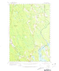
1958 Map of Amity
USGS Topo · Published 1967About this map
Wilcox Settlement and Estabrook Settlement anchor the landscape of southeastern Aroostook County, highlighting the dispersed nature of Maine’s rural homesteads during the mid-20th century. The international boundary between the United States and Canada is clearly defined, with the U S Customs station at Orient and the neighboring settlement of Fosterville marking a primary crossing point into New Brunswick. The map reflects a community supported by local institutions, featuring numerous district schools like Skedgell Sch and Reed Sch, alongside the Grange Hall in North Amity. Heavy woods and wetlands dominate the terrain, from Coffin Bog in the north to the Mattawamkeag River in the south. Notable elevations like Mitchel Mtn, which supported a lookout tower, provide vantage points over the complex network of waterways, including Tenmile Lake and the North Branch Meduxnekeag River.
Find a feature on this map
115 named features on this map. Tap any name to fly to it.
Don’t see what you’re looking for? This feature index may not catch every label — zoom into the map to look around manually.
Map Details
Editions of this 1958 Amity Map
3 editions found
Other maps of this area

1937 · Smyrna Mills
USGS Topo · 1:62,500

1938 · Houlton
USGS Topo · 1:62,500

1940 · Danforth
USGS Topo · 1:62,500

1940 · Amity
USGS Topo · 1:62,500

1940 · Forest
USGS Topo · 1:62,500

1941 · Danforth
USGS Topo · 1:62,500

1941 · Amity
USGS Topo · 1:62,500

1941 · Mattawamkeag Lake
USGS Topo · 1:62,500

1941 · Wytopitlock
USGS Topo · 1:62,500

1942 · Forest
USGS Topo · 1:62,500