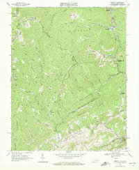
1968 Map of Amonate
USGS Topo · Published 1972About this map
The coal-rich borderlands of Virginia and West Virginia are extensively detailed in this 1968 survey, where industrial activity and complex topography define the landscape. The Norfolk and Western railroad follows the valleys of Beech Fork and Dry Fork, serving as the primary corridor for a region dominated by strip mines, mine dumps, and a network of gas wells. These extractive industries are interspersed with tight-knit settlements like Amonate, Vallscreek, and Harman, which are situated along the narrow bottoms between massive ridges.
Find a feature on this map
55 named features on this map. Tap any name to fly to it.
Don’t see what you’re looking for? This feature index may not catch every label — zoom into the map to look around manually.
Map Details
Editions of this 1968 Amonate Map
2 editions found
Other maps of this area

1891 · Tazewell
USGS Topo · 1:125,000

1895 · Tazewell
USGS Topo · 1:125,000

1897 · Tazewell
USGS Topo · 1:125,000

1910 · Iaeger
USGS Topo · 1:48,000

1912 · Pounding Mill
USGS Topo · 1:62,500

1912 · Iaeger
USGS Topo · 1:62,500

1912 · Welch
USGS Topo · 1:62,500

1914 · Iaeger
USGS Topo · 1:48,000

1915 · Richlands
USGS Topo · 1:48,000

1916 · Pounding Mill
USGS Topo · 1:62,500