
1974 Map of Amy
USGS Topo · Published 1976About this map
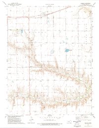
Atchison Topeka and Santa Fe railroad tracks cut a straight horizontal line across the northern portion of this High Plains landscape, anchoring the small settlement of Amy. The terrain is defined by the winding course of the South Fork Walnut Creek, which carves a modest valley through the flat agricultural townships of Blaine, Cleveland, and Dighton.
Find a feature on this map
9 named features on this map. Tap any name to fly to it.
Don’t see what you’re looking for? This feature index may not catch every label — zoom into the map to look around manually.
Map Details
Editions of this 1974 Amy Map
This is the sole edition of this map. No revisions or reprints were ever made.
Other maps of this area

1955 · Scott City
USGS Topo · 1:250,000

1958 · Scott City
USGS Topo · 1:250,000

1974 · Dighton SW
USGS Topo · 1:24,000

1974 · Amy SE
USGS Topo · 1:24,000

1974 · Dighton
USGS Topo · 1:24,000

1974 · Amy SW
USGS Topo · 1:24,000

1974 · Grigston
USGS Topo · 1:24,000

1974 · Manning
USGS Topo · 1:24,000

1974 · Healy
USGS Topo · 1:24,000
1974 · Shields
USGS Topo · 1:24,000