
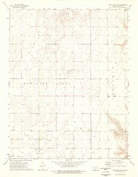
1974 Map of Amy SE
USGS Topo · Published 1976About this map
Sutton Cem and a nearby Townhall sit atop the high plains in the northwestern reaches of this Kansas quadrangle, marking the center of local civic and family life during the mid-1970s. The landscape is defined by the ephemeral drainages of the S Fk Walnut Cr and Hackberry Creek, which carve subtle depressions across the agricultural terrain. Surveyed and field-checked just before publication in 1976, the map records the township boundaries of Blaine, Cleveland, and Garfield. Evidence of local excavation is found at the Caliche Pits, while the southern boundary highlights the transition between Lane County and Finney County. The map reveals a highly structured section-line road network characteristic of the Great Plains, supporting a sparse but organized rural community.
Find a feature on this map
9 named features on this map. Tap any name to fly to it.
Don’t see what you’re looking for? This feature index may not catch every label — zoom into the map to look around manually.
Map Details
Editions of this 1974 Amy SE Map
This is the sole edition of this map. No revisions or reprints were ever made.
Other maps of this area

1955 · Scott City
USGS Topo · 1:250,000

1958 · Scott City
USGS Topo · 1:250,000

1974 · Ravanna
USGS Topo · 1:24,000
1974 · Scott City 4 NW
USGS Topo · 1:24,000

1974 · Dighton SW
USGS Topo · 1:24,000

1974 · Dighton
USGS Topo · 1:24,000

1974 · Scott City 4 NE
USGS Topo · 1:24,000

1974 · Amy SW
USGS Topo · 1:24,000

1974 · Grigston
USGS Topo · 1:24,000

1974 · Amy
USGS Topo · 1:24,000