
1974 Map of Dighton
USGS Topo · Published 1976About this map
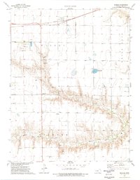
Dighton serves as the central hub on this mid-1970s survey of Lane County, exhibiting the organized grid of a High Plains county seat. The town's infrastructure includes a Fairground, a Landing Field, and a local Golf Course, reflecting a settled agricultural community. Transportation and commerce are anchored by the Atchison Topeka and Santa Fe railroad, which runs through the northern portion of the map alongside various specialized sites like a Drive-in Theater and a designated Rest Area.
Find a feature on this map
20 named features on this map. Tap any name to fly to it.
Don’t see what you’re looking for? This feature index may not catch every label — zoom into the map to look around manually.
Map Details
Editions of this 1974 Dighton Map
This is the sole edition of this map. No revisions or reprints were ever made.
Other maps of this area

1955 · Scott City
USGS Topo · 1:250,000

1958 · Scott City
USGS Topo · 1:250,000

1974 · Dighton SW
USGS Topo · 1:24,000

1974 · Amy SE
USGS Topo · 1:24,000

1974 · Alamota
USGS Topo · 1:24,000

1974 · Dighton SE
USGS Topo · 1:24,000

1974 · Amy
USGS Topo · 1:24,000

1974 · Healy
USGS Topo · 1:24,000

1974 · Shields SE
USGS Topo · 1:24,000
1974 · Shields
USGS Topo · 1:24,000