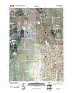
2011 Map of Ana River
USGS Topo · Published 2011About this map
Ana Reservoir and the Ana River Dam control the flow of water through this high desert landscape of Lake County, where the desert floor meets the northern edges of Summer Lake. The presence of several established agricultural outposts, such as River Ranch, Carlon Ranch, and Thousand Springs Ranch, indicates a long-standing reliance on the local hydrography and springs for cattle and land management.
Find a feature on this map
15 named features on this map. Tap any name to fly to it.
Don’t see what you’re looking for? This feature index may not catch every label — zoom into the map to look around manually.
Map Details
Editions of this 2011 Ana River Map
This is the sole edition of this map. No revisions or reprints were ever made.
Other maps of this area

1955 · Crescent
USGS Topo · 1:250,000

1955 · Klamath Falls
USGS Topo · 1:250,000

1957 · Crescent
USGS Topo · 1:250,000

1958 · Crescent
USGS Topo · 1:250,000

1958 · Klamath Falls
USGS Topo · 1:250,000

1966 · Summer Lake
USGS Topo · 1:24,000

1966 · Fremont Point
USGS Topo · 1:24,000

1970 · Crescent
USGS Topo · 1:250,000

1974 · Lake Abert
USGS Topo · 1:100,000
1982 · Egli Rim
USGS Topo · 1:24,000