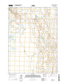
2014 Map of Ana River
USGS Topo · Published 2014About this map
The Ana River meanders through the high desert landscape of Lake County, feeding a complex of alkaline basins and seasonal wetlands in the early 21st century. This arid region is defined by its vital water sources, including the namesake river and Buckhorn Spring, which supported the early agricultural development indicated by the Summer Lake ID Canal. The map reveals a transition from open water at Schoolhouse Lake to the broad, marshy margins of Summer Lake and Rest Lake, illustrating the hydrological sensitivity of the Great Basin terrain.
Find a feature on this map
15 named features on this map. Tap any name to fly to it.
Don’t see what you’re looking for? This feature index may not catch every label — zoom into the map to look around manually.
Map Details
Editions of this 2014 Ana River Map
This is the sole edition of this map. No revisions or reprints were ever made.
Other maps of this area

1955 · Crescent
USGS Topo · 1:250,000

1955 · Klamath Falls
USGS Topo · 1:250,000

1957 · Crescent
USGS Topo · 1:250,000

1958 · Crescent
USGS Topo · 1:250,000

1958 · Klamath Falls
USGS Topo · 1:250,000

1966 · Summer Lake
USGS Topo · 1:24,000

1966 · Fremont Point
USGS Topo · 1:24,000

1970 · Crescent
USGS Topo · 1:250,000

1974 · Lake Abert
USGS Topo · 1:100,000
1982 · Egli Rim
USGS Topo · 1:24,000