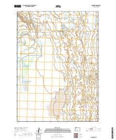
2020 Map of Ana River
USGS Topo · Published 2020About this map
Ana River flows through the northern reaches of this Lake County landscape, a vital water source in the high desert of south-central Oregon. The river’s path is clearly defined as it moves toward the expansive basin of Summer Lake, which dominates the southwestern portion of the map. The interplay between these water features and the arid environment is further highlighted by Buckhorn Spring, a localized water point that speaks to the traditional importance of reliable springs for cattle ranching and early travel in this remote region. Transportation in the area is represented by Co HWY 4-17, a route that provides access through the expansive grid of the Public Land Survey System, marked here by townships and ranges including t30s r17e and t31s r18e.
Find a feature on this map
8 named features on this map. Tap any name to fly to it.
Don’t see what you’re looking for? This feature index may not catch every label — zoom into the map to look around manually.
Map Details
Editions of this 2020 Ana River Map
This is the sole edition of this map. No revisions or reprints were ever made.
Other maps of this area

1955 · Crescent
USGS Topo · 1:250,000

1955 · Klamath Falls
USGS Topo · 1:250,000

1957 · Crescent
USGS Topo · 1:250,000

1958 · Crescent
USGS Topo · 1:250,000

1958 · Klamath Falls
USGS Topo · 1:250,000

1966 · Summer Lake
USGS Topo · 1:24,000

1966 · Fremont Point
USGS Topo · 1:24,000

1970 · Crescent
USGS Topo · 1:250,000

1974 · Lake Abert
USGS Topo · 1:100,000
1982 · Egli Rim
USGS Topo · 1:24,000