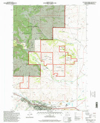
1996 Map of Anaconda North
USGS Topo · Published 1998About this map
Anaconda serves as the industrial and civic anchor of this landscape, its urban grid tightly clustered along Commercial Avenue and Main Street. The town is characterized by a high concentration of institutional landmarks, including the Dwyer School, Junior High School, and the Community Hospital, reflecting its role as a regional hub in the late 20th century. To the west, Washoe Park and the adjacent Fish Hatchery border Warm Springs Creek, offering a recreational contrast to the industrial scars of the Open Pit Mine and extensive Tailings piles nearby.
Find a feature on this map
50 named features on this map. Tap any name to fly to it.
Don’t see what you’re looking for? This feature index may not catch every label — zoom into the map to look around manually.
Map Details
Editions of this 1996 Anaconda North Map
This is the sole edition of this map. No revisions or reprints were ever made.
Other maps of this area

1889 · Helena
USGS Topo · 1:250,000

1893 · Helena
USGS Topo · 1:250,000

1899 · Helena
USGS Topo · 1:250,000

1903 · Helena
USGS Topo · 1:250,000

1908 · Philipsburg
USGS Topo · 1:125,000

1947 · Butte
USGS Topo · 1:250,000

1958 · Butte
USGS Topo · 1:250,000

1960 · Butte
USGS Topo · 1:250,000

1961 · Anaconda
USGS Topo · 1:62,500

1962 · Butte
USGS Topo · 1:250,000