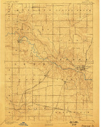
1890 Map of Anamosa
USGS Topo · Published 1898About this map
The Wapsipinicon River carves a winding path through the borderlands of Linn and Jones counties, anchoring a landscape defined by late-19th-century agriculture and expanding rail networks. At the heart of the region, Anamosa serves as a significant hub where the C. and N. W. line meets the extensive Chicago Milwaukee and St. Paul Railroad. This rail system connects a string of prairie settlements, including Springville, Viola, and Martelle, each situated within a grid of township boundaries such as Brown and Fairview. Beyond the main river corridor, Buffalo Creek and Crab Apple Creek drain the surrounding uplands, while smaller villages like Waubeek and Prairieburg reflect the dispersed settlement pattern of the era. The mapping by W. J. Peters reveals a transition from the river's dissected valley to the high, open fields of Castle Grove.
Find a feature on this map
24 named features on this map. Tap any name to fly to it.
Don’t see what you’re looking for? This feature index may not catch every label — zoom into the map to look around manually.
Map Details
Editions of this 1890 Anamosa Map
2 editions found
Other maps of this area

1887 · Cedar Rapids
USGS Topo · 1:62,500

1888 · Marion
USGS Topo · 1:62,500

1889 · Tipton
USGS Topo · 1:62,500

1889 · Marion
USGS Topo · 1:62,500

1890 · Tipton
USGS Topo · 1:62,500

1890 · Anamosa
USGS Topo · 1:62,500
1891 · Monticello
USGS Topo · 1:62,500

1891 · Mechanicsville
USGS Topo · 1:62,500

1891 · Cedar Rapids
USGS Topo · 1:62,500

1894 · Mechanicsville
USGS Topo · 1:62,500