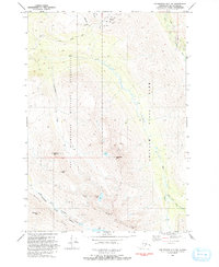
1993 Map of Anchorage A-7 NW
USGS Topo · Published 1993About this map
Fort Richardson Military Reservation occupies a significant portion of this high-altitude landscape, where military infrastructure meets the eastern reaches of the Anchorage area. The survey illustrates the intersection of recreation and defense, featuring the Alpenglow Ski Area and its associated Ski Lift infrastructure tucked into the mountains. This 1993 edition documents the transition into Chugach State Park, showing a terrain defined by sharp ridges and deep valleys carved by Ship Creek and the South Fork Eagle River.
Find a feature on this map
21 named features on this map. Tap any name to fly to it.
Don’t see what you’re looking for? This feature index may not catch every label — zoom into the map to look around manually.
Map Details
Editions of this 1993 Anchorage A-7 NW Map
This is the sole edition of this map. No revisions or reprints were ever made.
Other maps of this area

1951 · Anchorage
USGS Topo · 1:250,000

1952 · Anchorage A-8
USGS Topo · 1:63,360

1952 · Anchorage B-8
USGS Topo · 1:63,360

1953 · Anchorage A-8
USGS Topo · 1:63,360

1953 · Anchorage B-8
USGS Topo · 1:63,360

1960 · Anchorage B-7
USGS Topo · 1:63,360

1960 · Anchorage A-7
USGS Topo · 1:63,360

1962 · Anchorage
USGS Topo · 1:250,000

1965 · Anchorage B-8
USGS Topo · 1:63,360

1979 · Anchorage B-7 SW
USGS Topo · 1:25,000