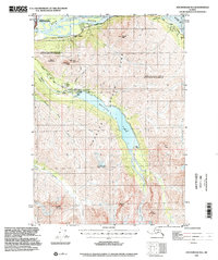
1994 Map of Anchorage B-6
USGS Topo · Published 2002About this map
Glacial waters and steep mountain ridges dominate this mid-century topographic profile of the northern Chugach Range. The central focus is Eklutna Lake, a massive reservoir fed by the Eklutna Glacier and managed via the Eklutna Dam. Infrastructure for power generation and water transport is evident along the Eklutna River, including the Eklutna Powerhouse and several pumping stations that speak to the region's role in supporting the growth of the nearby Anchorage municipality.
Find a feature on this map
29 named features on this map. Tap any name to fly to it.
Don’t see what you’re looking for? This feature index may not catch every label — zoom into the map to look around manually.
Map Details
Editions of this 1994 Anchorage B-6 Map
This is the sole edition of this map. No revisions or reprints were ever made.
Other maps of this area

1950 · Anchorage C-7
USGS Topo · 1:63,360

1951 · Anchorage
USGS Topo · 1:250,000

1951 · Anchorage C-6
USGS Topo · 1:63,360

1951 · Anchorage C-7
USGS Topo · 1:63,360

1951 · Anchorage C-5
USGS Topo · 1:63,360

1952 · Anchorage C-7
USGS Topo · 1:63,360

1952 · Anchorage C-5
USGS Topo · 1:63,360

1960 · Anchorage A-6
USGS Topo · 1:63,360

1960 · Anchorage B-7
USGS Topo · 1:63,360

1960 · Anchorage B-6
USGS Topo · 1:63,360