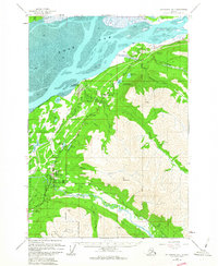
1960 Map of Anchorage B-7
USGS Topo · Published 1963About this map
The corridor between the Knik Arm and the towering peaks of Mt Magnificent reveals the early development of the Anchorage outskirts during the mid-century. Several distinct settlements are established along the Alaska Railroad and the Glenn Highway, including Eklutna, Birchwood, and Eagle River. The landscape is a mix of strategic military lands within the Fort Richardson Military Reservation and recreational spaces like Camp Gorsuch on the shores of Mirror Lake. Transport and logistics are central to the area's identity, evidenced by the Birchwood Auxiliary Airfield and numerous landing areas. The map details the drainage systems of Eagle River and Peters Creek, where camping grounds like Peters Creek Campground and Ford Campground suggest the growing importance of this region for local transit and outdoor life before the full expansion of the neighboring city.
Find a feature on this map
46 named features on this map. Tap any name to fly to it.
Don’t see what you’re looking for? This feature index may not catch every label — zoom into the map to look around manually.
Map Details
Editions of this 1960 Anchorage B-7 Map
4 editions found


Other maps of this area

1950 · Anchorage C-8
USGS Topo · 1:63,360

1950 · Anchorage C-7
USGS Topo · 1:63,360

1951 · Anchorage
USGS Topo · 1:250,000

1951 · Anchorage C-6
USGS Topo · 1:63,360

1951 · Anchorage C-7
USGS Topo · 1:63,360

1952 · Anchorage C-7
USGS Topo · 1:63,360

1952 · Anchorage C-8
USGS Topo · 1:63,360

1952 · Anchorage A-8
USGS Topo · 1:63,360

1952 · Anchorage B-8
USGS Topo · 1:63,360

1953 · Anchorage A-8
USGS Topo · 1:63,360