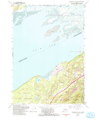
1979 Map of Anchorage B-7 NW
USGS Topo · Published 1993About this map
Birchwood and Chugiak define the residential character of the northern Anchorage area during the late twentieth century, situated between the tidal flats of the Knik Arm and the rising slopes of Chugach State Park. This period of development is marked by the prominence of the Glenn Highway and the Old Glenn Highway, which served as the primary arteries for a growing commuter population. The landscape transition from the silty mud of Coffee Point to the glacial features of the Elmendorf Moraine illustrates the geological complexity of the Cook Inlet region.
Find a feature on this map
34 named features on this map. Tap any name to fly to it.
Don’t see what you’re looking for? This feature index may not catch every label — zoom into the map to look around manually.
Map Details
Editions of this 1979 Anchorage B-7 NW Map
3 editions found
Other maps of this area

1950 · Anchorage C-8
USGS Topo · 1:63,360

1950 · Anchorage C-7
USGS Topo · 1:63,360

1951 · Anchorage
USGS Topo · 1:250,000

1951 · Anchorage C-7
USGS Topo · 1:63,360

1952 · Anchorage C-7
USGS Topo · 1:63,360

1952 · Anchorage C-8
USGS Topo · 1:63,360

1952 · Anchorage B-8
USGS Topo · 1:63,360

1953 · Anchorage B-8
USGS Topo · 1:63,360

1960 · Anchorage B-7
USGS Topo · 1:63,360

1962 · Anchorage
USGS Topo · 1:250,000