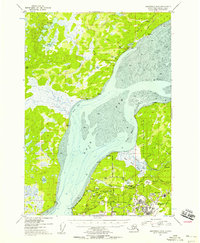
1953 Map of Anchorage B-8
USGS Topo · Published 1958About this map
The Iditarod Trail traverses the northern reaches of this coastal landscape, a reminder of the overland routes that predated the industrial growth seen further south. This 1950s survey documents a critical period of military expansion in the region, centered on Elmendorf Air Force Base and Fort Richardson. The map details the complex infrastructure of these installations, from the Alaska Railroad spurs and the Glenn Highway to the Kermit Roosevelt Memorial Dam. Along the shores of Knik Arm, the geography transitions from the tidal Eagle River Flats to the small settlement of Knik. Further inland, numerous small lakes such as Otter Lake, Triangle Lake, and Green Lake dot the terrain, while landmarks like Sandpiper Lodge and the Airstrip (Alex) provide evidence of the era's local aviation and hospitality hubs.
Find a feature on this map
57 named features on this map. Tap any name to fly to it.
Don’t see what you’re looking for? This feature index may not catch every label — zoom into the map to look around manually.
Map Details
Editions of this 1953 Anchorage B-8 Map
2 editions found

Other maps of this area

1949 · Tyonek
USGS Topo · 1:250,000

1950 · Anchorage C-8
USGS Topo · 1:63,360

1950 · Anchorage C-7
USGS Topo · 1:63,360

1951 · Anchorage
USGS Topo · 1:250,000

1951 · Tyonek
USGS Topo · 1:250,000

1951 · Anchorage C-7
USGS Topo · 1:63,360

1951 · Tyonek A-1
USGS Topo · 1:63,360

1952 · Anchorage C-7
USGS Topo · 1:63,360

1952 · Anchorage C-8
USGS Topo · 1:63,360

1952 · Tyonek C-1
USGS Topo · 1:63,360