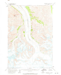
1960 Map of Anchorage C-2
USGS Topo · Published 1971About this map
Matanuska Glacier dominates the central corridor of this Alaskan topographic study, providing a frozen record of the landscape as it appeared in the mid-twentieth century. Based on aerial photography from the 1950s and field annotations from 1960, the map illustrates the complex ice patterns and numerous Crevasses that define the glacier's surface as it flows through the Chugach Mountains. To the west, the prominent peak of Mount Wickersham stands as a landmark overlooking the ice-carved valley. This edition is particularly valuable for researchers tracking glacial movement and topographical changes, as it captures the extent of the ice before later decades of significant recession. The map also delineates unsurveyed land lines predetermined by the Bureau of Land Management, reflecting the ongoing administrative mapping of the Alaskan interior during the early statehood era.
Find a feature on this map
3 named features on this map. Tap any name to fly to it.
Don’t see what you’re looking for? This feature index may not catch every label — zoom into the map to look around manually.
Map Details
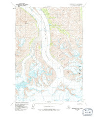
Editions of this 1960 Anchorage C-2 Map
3 editions found
Other maps of this area

1948 · Anchorage D-3
USGS Topo · 1:63,360

1948 · Anchorage D-2
USGS Topo · 1:63,360

1948 · Anchorage D-1
USGS Topo · 1:63,360

1951 · Anchorage
USGS Topo · 1:250,000

1951 · Anchorage D-1
USGS Topo · 1:63,360

1952 · Anchorage D-2
USGS Topo · 1:63,360

1952 · Anchorage D-3
USGS Topo · 1:63,360

1960 · Anchorage C-2
USGS Topo · 1:63,360

1960 · Anchorage B-1
USGS Topo · 1:63,360

1960 · Anchorage C-3
USGS Topo · 1:63,360