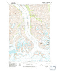
1960 Map of Anchorage C-2
USGS Topo · Published 1992About this map
Matanuska Glacier dominates the central corridor of this survey, recorded through aerial photography in the 1950s and field annotated in 1960. The massive ice field is flanked by a series of prominent summits, most notably Mount Wickersham to the northwest. To the southeast, the landscape is defined by a cluster of peaks named for Nordic nations, including Denmark Peak, Norway Peak, Finland Peak, and Sweden Peak. The map provides a detailed topographic record of the glacial extent and drainage patterns before later decades of environmental change. This document serves as a critical baseline for understanding the high-elevation terrain of the Matanuska-Susitna Borough during the mid-twentieth century.
Find a feature on this map
6 named features on this map. Tap any name to fly to it.
Don’t see what you’re looking for? This feature index may not catch every label — zoom into the map to look around manually.
Map Details
Editions of this 1960 Anchorage C-2 Map
3 editions found
Other maps of this area

1948 · Anchorage D-3
USGS Topo · 1:63,360

1948 · Anchorage D-2
USGS Topo · 1:63,360

1948 · Anchorage D-1
USGS Topo · 1:63,360

1951 · Anchorage
USGS Topo · 1:250,000

1951 · Anchorage D-1
USGS Topo · 1:63,360

1952 · Anchorage D-2
USGS Topo · 1:63,360

1952 · Anchorage D-3
USGS Topo · 1:63,360

1960 · Anchorage C-2
USGS Topo · 1:63,360

1960 · Anchorage B-1
USGS Topo · 1:63,360

1960 · Anchorage C-3
USGS Topo · 1:63,360