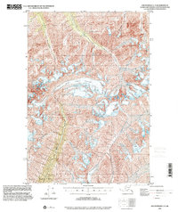
1994 Map of Anchorage C-4
USGS Topo · Published 2001About this map
The Metal Creek Glacier dominates the central landscape of this high-altitude topographic study, feeding the braided drainage of Metal Creek. Based on topography compiled in 1950 with updated planimetry from 1994, the map reveals a wilderness shaped by massive ice flows and sharp elevation changes in the Chugach Mountains. Notable watercourses like Carbon Creek and Coal Creek slice through the northern ridges, while Cottonwood Creek drains the southern slopes. This map captures the remote character of the Matanuska-Susitna region before the 21st century, showing a landscape defined entirely by its glacial geology and alpine hydrology rather than human settlement, making it an essential reference for geologists and wilderness historians studying Alaskas glacial retreat.
Find a feature on this map
5 named features on this map. Tap any name to fly to it.
Don’t see what you’re looking for? This feature index may not catch every label — zoom into the map to look around manually.
Map Details
Editions of this 1994 Anchorage C-4 Map
This is the sole edition of this map. No revisions or reprints were ever made.
Other maps of this area

1948 · Anchorage D-3
USGS Topo · 1:63,360

1948 · Anchorage D-4
USGS Topo · 1:63,360

1949 · Anchorage D-5
USGS Topo · 1:63,360

1951 · Anchorage
USGS Topo · 1:250,000

1951 · Anchorage C-5
USGS Topo · 1:63,360

1952 · Anchorage D-5
USGS Topo · 1:63,360

1952 · Anchorage D-4
USGS Topo · 1:63,360

1952 · Anchorage D-3
USGS Topo · 1:63,360

1952 · Anchorage C-5
USGS Topo · 1:63,360

1960 · Anchorage C-5
USGS Topo · 1:63,360