
1952 Map of Anchorage C-7
USGS Topo · Published 1952About this map
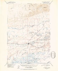
Wasilla serves as the primary hub of activity in this 1952 topographic survey, situated where The Alaska Railroad intersects a developing network of rural roads. The landscape transition is stark, shifting from the high elevations of Bald Mountain Ridge and Government Peak in the north to the low-lying lacustrine plains in the south. The presence of the Thorpe Mine near Grubstake Gulch points to the area's early mining interests, while the proliferation of named water bodies like Lucile Lake, Finger Lake, and Wasilla Lake indicates a territory defined by its glacial hydrology. Transport is already anchoring the region, with the Airport and early corridors like Fishhook Road and Seward Meridian Road providing the framework for the modern Matanuska-Susitna Valley's growth.
Find a feature on this map
53 named features on this map. Tap any name to fly to it.
Don’t see what you’re looking for? This feature index may not catch every label — zoom into the map to look around manually.
Map Details
Editions of this 1952 Anchorage C-7 Map
2 editions found
Other maps of this area

1949 · Anchorage D-7
USGS Topo · 1:63,360

1949 · Anchorage D-8
USGS Topo · 1:63,360

1950 · Anchorage C-8
USGS Topo · 1:63,360

1950 · Anchorage D-6
USGS Topo · 1:63,360

1950 · Anchorage C-7
USGS Topo · 1:63,360

1951 · Anchorage
USGS Topo · 1:250,000

1951 · Anchorage C-6
USGS Topo · 1:63,360

1951 · Anchorage C-7
USGS Topo · 1:63,360

1951 · Anchorage D-8
USGS Topo · 1:63,360

1951 · Anchorage D-7
USGS Topo · 1:63,360