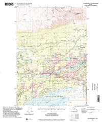
1994 Map of Anchorage C-7
USGS Topo · Published 2002About this map
Wasilla and the surrounding Matanuska-Susitna Valley are shown in detail during a period of significant regional growth in the early 1990s. The landscape is defined by its extensive network of water bodies, including Lucile Lake, Wasilla Lake, and Cottonwood Lake, which supported various seaplane operations such as the Wasilla Seaplane Base. To the north, the terrain rises sharply toward Bald Mountain Ridge and Government Peak, where the Thorpe Mine sits near Grubstake Gulch. This survey captures the critical transportation corridors of the era, from the Alaska Railroad and George Parks Highway to the historic Iditarod Trail crossing the lower wetlands. The southern portion of the map is dominated by the Palmer Hay Flats State Game Refuge and the tidal reaches of the Knik Arm, illustrating the meeting of suburban expansion and protected Alaskan wilderness.
Find a feature on this map
104 named features on this map. Tap any name to fly to it.
Don’t see what you’re looking for? This feature index may not catch every label — zoom into the map to look around manually.
Map Details
Editions of this 1994 Anchorage C-7 Map
This is the sole edition of this map. No revisions or reprints were ever made.
Other maps of this area

1949 · Anchorage D-7
USGS Topo · 1:63,360

1949 · Anchorage D-8
USGS Topo · 1:63,360

1950 · Anchorage C-8
USGS Topo · 1:63,360

1950 · Anchorage D-6
USGS Topo · 1:63,360

1950 · Anchorage C-7
USGS Topo · 1:63,360

1951 · Anchorage
USGS Topo · 1:250,000

1951 · Anchorage C-6
USGS Topo · 1:63,360

1951 · Anchorage C-7
USGS Topo · 1:63,360

1951 · Anchorage D-8
USGS Topo · 1:63,360

1951 · Anchorage D-7
USGS Topo · 1:63,360